
DALLAS —
Live radar
LIVE BLOG:
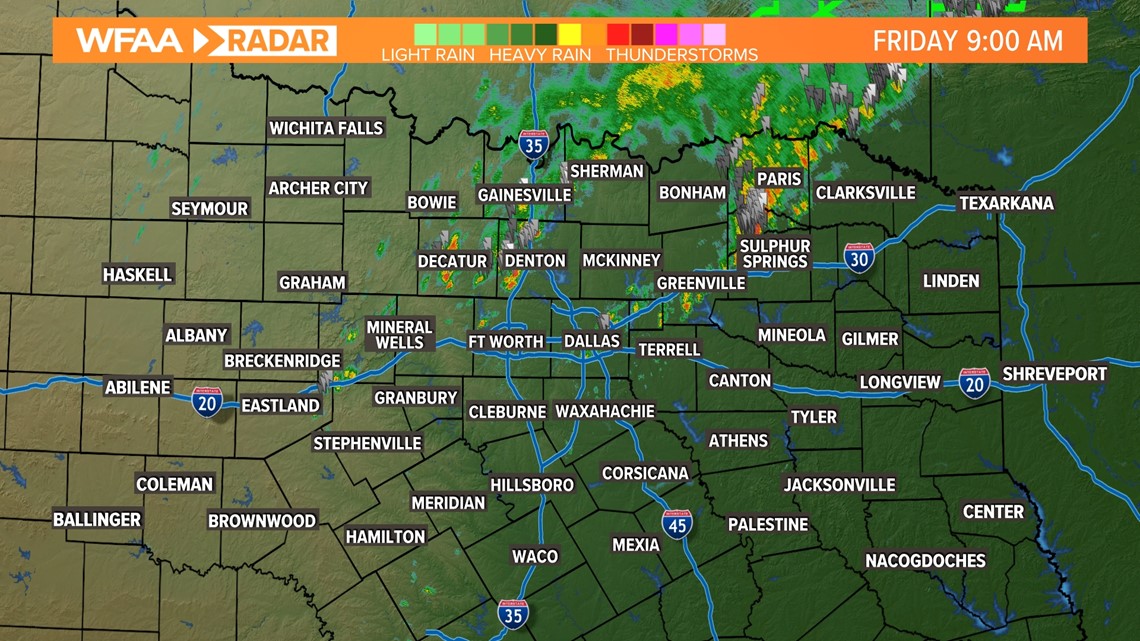
9:00 a.m.: Severe Thunderstorm Watch has EXPIRED for all of North Texas. Some areas will continue to see non-severe storms. Heavy rain, lightning and gusty winds still possible for the next couple of hours.

8:15 a.m.: Severe Thunderstorm Watch UPDATE - Tarrant, Dallas, and Denton counties have been removed from the watch. A few counties remain in the watch until 9am.
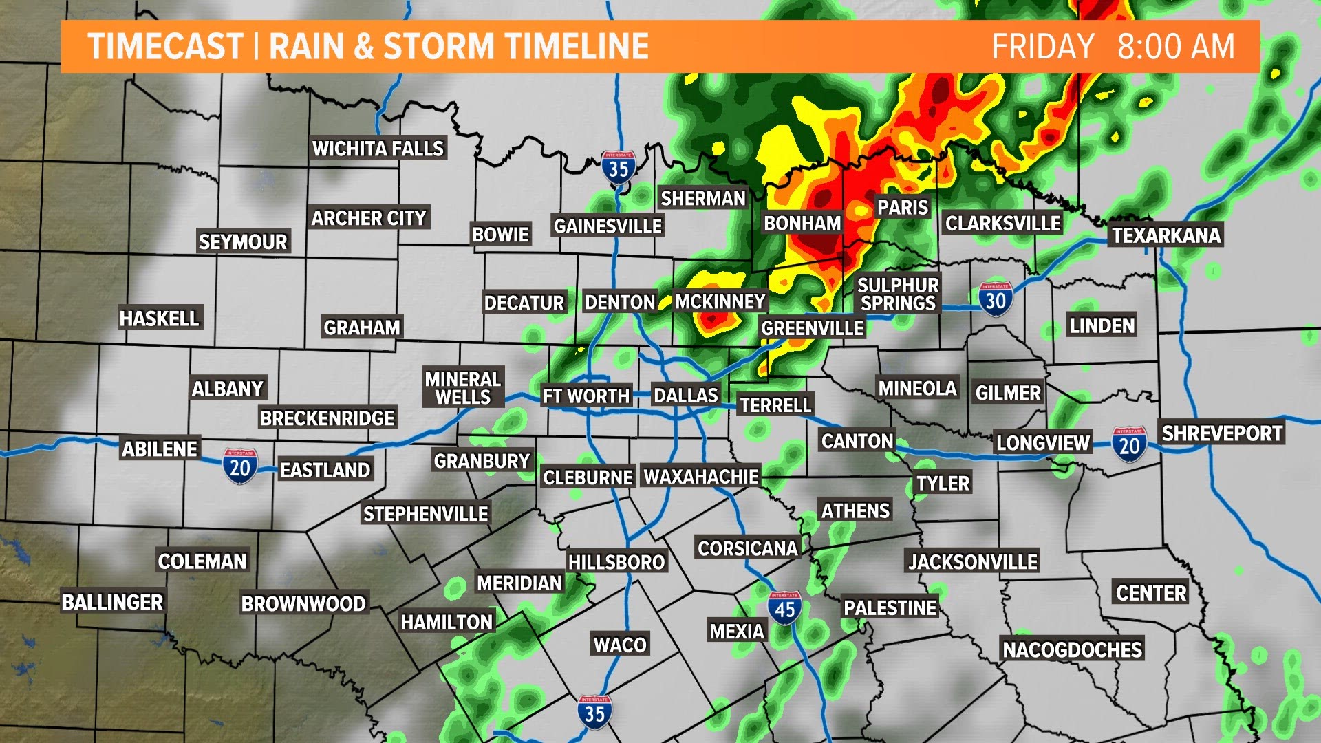
7:45 a.m.: No active warnings are in place across North Texas, Heavy rain, lightning and gusty winds are still possible for the next few hours. Drier weather moves in this afternoon.
7 a.m.: No active warnings for DFW, but there are still areas of heavy rain, lightning and gusty winds. This will temporarily lower visibility at times.
6:40 a.m.: NEW Severe Thunderstorm Warning includes Collin county until 7:30 am. A strong storm located near McKinney is moving NE at 45 mph. This could produce 60 mph wind gusts.
6:30 a.m.: Severe Thunderstorm Warning for Collin, Fannin, and Grayson County until 7:30 a.m.
6:15 a.m.: No active warnings in place across North Texas. Moderate to heavy rain along with lightning and some gusty winds will still be possible for areas east of I-35. Severe thunderstorm watch remains in place for some of our counties.
5:23 a.m.: Severe Thunderstorm Warning for Cooke, Denton, Grayson and Wise County until 6:15 a.m.
5:12 a.m.: Severe Thunderstorm Warning for Hood, Johnson, Parker, Somervell and Tarrant County until 6:15 a.m.
4:55 a.m.: Tornado Warning for Parker and Wise County until 5:30am.
4:30 a.m.: NEW Severe Thunderstorm Warning for Comanche, Erath, Hood, Palo Pinto, Parker and Somervell counties until 5:45 am. This is for a line of storms moving into these counties. The line is moving east at 50 mph. Quarter size hail and strong winds possible here.
4:18 a.m.: Severe thunderstorm watch has been extended to include more North Texas counties until 9am.
Thunderstorm timeline
A Severe Thunderstorm Watch removes Dallas, Tarrant, Denton counties. A few locations still under the watch until 9am. Storms moving into this area are capable of producing 65 mph winds, large hail and a brief tornado. Counties west of the main line of storms have been removed from the watch.


An approaching cold front has produced a long line of showers and storms extending from north to south across North Texas. This line is moving from west to east through the morning.
The best thunderstorm chances come along the front Friday morning. The rain will end through the morning on Friday from west to east, with dry weather expected for the weekend.
With these storms, hail and strong winds look to be the main concern, but severe weather doesn't look to be widespread.
Here's the forecast timeline:
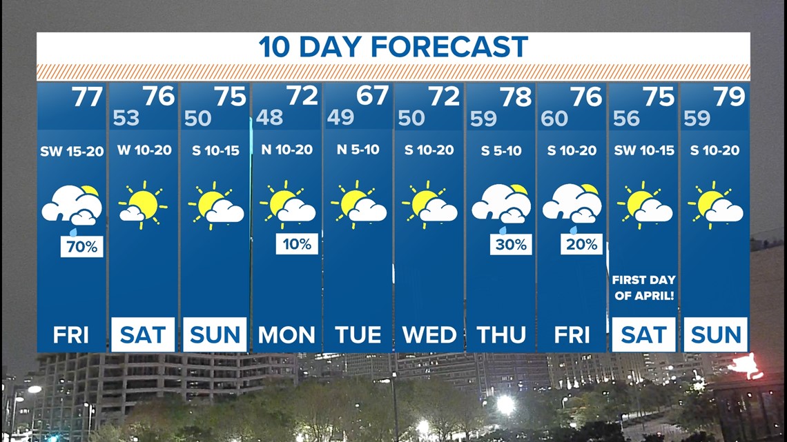
The next 10 days
After the storms exit Friday morning, the weekend looks great! Highs in the middle 70s and sunshine are in the forecast. Unfortunately, the winds won't get much better anytime soon.
More scattered storms are in the forecast next week.